Rocky Mountain National Park: The Complete Hiking and Visitor Guide for 2026
February 26, 2026
Rocky Mountain National Park covers 415 square miles of alpine tundra, glacier-carved valleys, and over 350 miles of hiking trails. It sits about 70 miles northwest of Denver, straddles the Continental Divide, and draws more than 4 million visitors a year. If you're planning a trip, this guide covers everything: the best hikes by difficulty, how to deal with timed entry permits, Trail Ridge Road logistics, wildlife viewing, camping options, and the gear you should bring.
What You'll Learn
- Getting There and Entrances
- Timed Entry Permits
- Best Hikes for Beginners
- Best Intermediate Hikes
- Best Advanced and Strenuous Hikes
- Trail Ridge Road
- Wildlife You'll Actually See
- Camping in the Park
- Best Time to Visit
- What to Bring
- Altitude Sickness and Safety
- Frequently Asked Questions
Getting There and Entrances
The park has two main entrances on the east side and one on the west:
Beaver Meadows Entrance (East) is the most popular and closest to Estes Park. From Denver, take I-25 north to US-36 west through Boulder and Lyons. About 90 minutes without traffic, but summer weekends can push that to two hours or more.
Fall River Entrance (East) is a few miles north of Beaver Meadows. Less crowded, and it's the entrance you want if you're heading straight to Fall River Road or the Alluvial Fan area.
Grand Lake Entrance (West) accesses the quieter west side of the park through the town of Grand Lake. This side sees a fraction of the east side's traffic and has some of the park's best backcountry access.
Park passes: A 7-day vehicle pass costs $30 (2026 rates). If you visit multiple national parks, the $80 America the Beautiful annual pass pays for itself in three visits.
Timed Entry Permits
RMNP has used timed entry reservations during peak season since 2020. The system runs from late May through mid-October and applies to the Bear Lake Road corridor and the rest of the park.
Two reservation windows exist:
- Bear Lake Road Corridor (5:00 AM - 6:00 PM): Required to access the park's most popular trailheads, including Bear Lake, Glacier Gorge, and Bierstadt Lake. This is the one that sells out fast.
- Rest of Park (9:00 AM - 3:00 PM): Covers Trail Ridge Road and all other areas except Bear Lake Road.
Reservations open on Recreation.gov and release in batches. Check the NPS website for exact 2026 dates, because the schedule shifts slightly each year. If you miss the window, arriving before 5:00 AM (Bear Lake) or 9:00 AM (rest of park) gets you in without a reservation.
Pro tip: Afternoons after 3:00 PM don't require reservations for the rest-of-park zone. Summer thunderstorms usually roll through between 1:00 and 3:00 PM, so a late afternoon arrival can give you clear skies and empty trails.
Best Hikes for Beginners
These trails are well-maintained, clearly marked, and manageable for most fitness levels. Don't underestimate the altitude, though. Even flat trails feel harder at 8,000 to 10,000 feet.
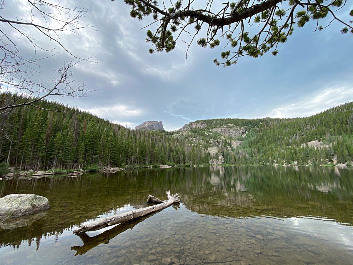
Bear Lake Loop (0.8 miles, easy)
The most accessible trail in the park. A flat, paved loop around an alpine lake with views of Hallett Peak and Flattop Mountain. Wheelchair accessible. Perfect if you're acclimating or hiking with kids. Gets extremely crowded by mid-morning in summer, so arrive early.
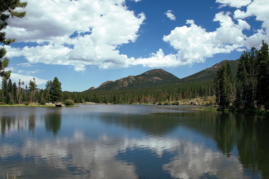
Sprague Lake Loop (0.8 miles, easy)
A flat, packed-gravel trail around a lake that reflects the Continental Divide on calm mornings. Less crowded than Bear Lake and just as scenic. Great for photography at sunrise.
Alberta Falls (1.6 miles round trip, easy-moderate)
One of the most rewarding short hikes in the park. A well-traveled trail from the Glacier Gorge trailhead leads to a 30-foot waterfall cascading over granite. Best flow is May through July during snowmelt. Go early to avoid the crowds.
Coyote Valley Trail (1.0 mile, easy)
On the west side near Grand Lake. A flat, paved trail through a meadow along the Colorado River. Excellent for wildlife, especially moose and elk at dawn and dusk. One of the park's hidden gems because most visitors stick to the east side.
Best Intermediate Hikes
These trails involve more elevation gain and longer distances. You should be comfortable hiking for 3 to 5 hours and handling rocky terrain.
Emerald Lake (3.6 miles round trip, moderate)
The crown jewel of the Bear Lake corridor. Starting from Bear Lake, you pass Nymph Lake (lily pads in summer), Dream Lake (stunning mountain reflections), and finally Emerald Lake tucked beneath Hallett Peak. About 650 feet of elevation gain. One of the most photographed spots in Colorado. Read our detailed Emerald Lake trail guide for the full breakdown.
Mills Lake (5.6 miles round trip, moderate)
From Glacier Gorge trailhead, you pass Alberta Falls and follow Glacier Creek to Mills Lake, which sits at the base of the Keyboard of the Winds ridge and Longs Peak. The granite slabs at the lake are perfect for lunch. About 750 feet of gain.
Bierstadt Lake (2.8 miles round trip, moderate)
A steep first half mile gives way to a flat walk through forest to a peaceful lake. Far fewer people than the Bear Lake trails despite being in the same corridor. Morning light on the lake with the Continental Divide backdrop is worth the early alarm.
Ouzel Falls (5.4 miles round trip, moderate)
Starting from the Wild Basin trailhead on the park's southeast side, this trail passes Copeland Falls and Calypso Cascades before reaching Ouzel Falls. Wild Basin sees a fraction of the Bear Lake traffic, and the three waterfalls make this one of the best bang-for-your-effort hikes in the park.
Best Advanced and Strenuous Hikes
These trails demand fitness, preparation, and respect for mountain conditions. Start early to avoid afternoon lightning.
Sky Pond (9.4 miles round trip, strenuous)
The consensus favorite among experienced RMNP hikers. The trail passes Alberta Falls, The Loch (a beautiful alpine lake), Timberline Falls (you'll scramble up wet rock beside it), Lake of Glass, and finally Sky Pond, surrounded by the Cathedral Spires. About 1,750 feet of gain. The scramble at Timberline Falls is the crux. Bring trekking poles and waterproof boots.
Flattop Mountain and Hallett Peak (9.2 miles round trip, strenuous)
Starting from Bear Lake, you climb steadily above treeline to Flattop Mountain (12,324 feet) with panoramic views of the Continental Divide. The optional 0.4-mile scramble to Hallett Peak (12,713 feet) adds exposure and Class 2 rock. About 2,850 feet of gain.
Chasm Lake (8.4 miles round trip, strenuous)
A high-alpine hike to a cirque lake directly beneath the Diamond face of Longs Peak. The trail crosses Peacock Pool and climbs through talus to the lake at 11,760 feet. Snow lingers into July most years. About 2,360 feet of gain.
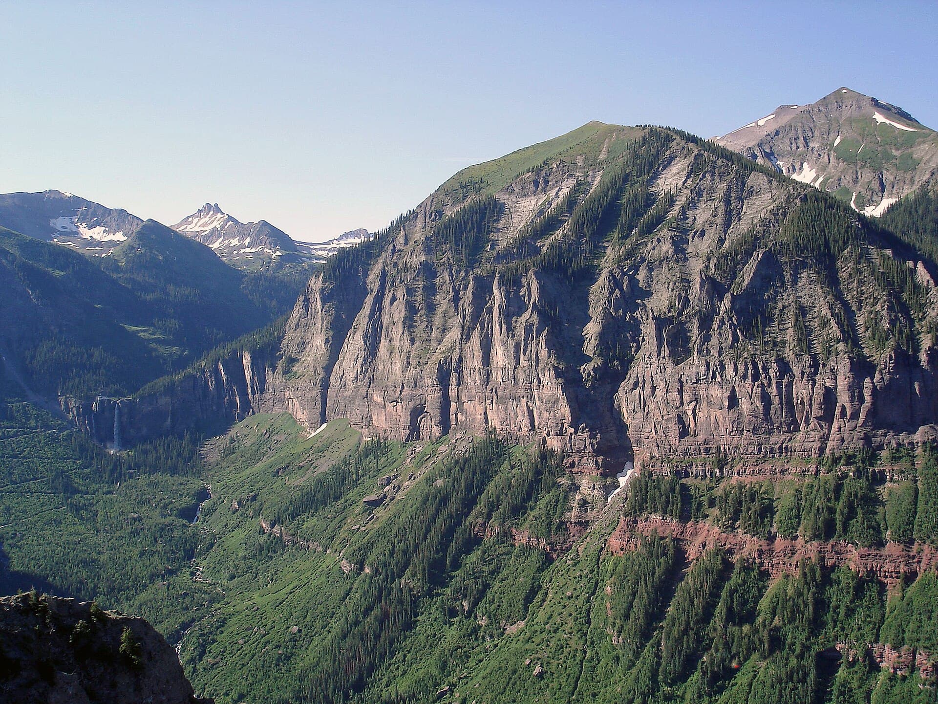
Longs Peak (14.3 miles round trip, very strenuous)
The only fourteener in the park at 14,259 feet. The Keyhole Route is the standard path and involves Class 3 scrambling with serious exposure on the Narrows, Trough, and Homestretch. This is not a casual hike. People die on Longs Peak. Start by 3:00 AM to summit before noon thunderstorms. Check our Colorado 14ers guide for more on preparing for fourteeners.
Trail Ridge Road
Trail Ridge Road is the highest continuously paved road in the United States, reaching 12,183 feet at its summit. It runs 48 miles between Estes Park and Grand Lake, crossing the Continental Divide at Milner Pass.
Open seasonally from late May through mid-October, depending on snowfall. The road closes at Many Parks Curve on the east and Colorado River Trailhead on the west during winter.
What to expect: The drive takes about two hours without stops, but plan for three or four. Key pulloffs include:
- Many Parks Curve (9,620 ft): Sweeping views of the Mummy Range and multiple glacial valleys
- Forest Canyon Overlook (11,716 ft): Look down into Forest Canyon and across to the Never Summer Mountains
- Alpine Visitor Center (11,796 ft): The highest visitor center in the NPS system. Gift shop, exhibits, and a short trail to an observation point
- Medicine Bow Curve (11,640 ft): Views of the Medicine Bow Mountains to the north
- Milner Pass (10,758 ft): The Continental Divide. Rain falling on the east side flows to the Atlantic; on the west, to the Pacific.
Driving tips: Temperatures at the summit can be 20 to 30 degrees colder than Estes Park. Bring layers even in August. Watch for marmots on the road. Don't rely on cell service above treeline.
Wildlife You'll Actually See
RMNP is one of the best parks in the system for wildlife viewing. Here's what's realistic:
Elk are everywhere, especially in the Kawuneeche Valley (west side) and around Moraine Park and Horseshoe Park (east side). During the fall rut (September through October), bull elk bugle at dawn and dusk. Keep 75 feet of distance and never get between a bull and his herd.
Mule deer are common throughout the park, particularly near the Beaver Meadows entrance and along Trail Ridge Road.
Moose frequent the west side, especially along the Colorado River Trail and in the Kawuneeche Valley. They're the most dangerous large animal in the park. Give them at least 75 feet, more if they have calves.
Bighorn sheep are occasionally spotted on Specimen Mountain and along Fall River Road. They're easier to find in winter when they come to lower elevations.
Marmots and pikas live above treeline. Marmots are the size of large cats and will absolutely try to eat your pack if you leave it unattended. Pikas are small, round, and make a distinctive high-pitched squeak from rock fields.
Black bears are present but rarely seen. Store food properly and carry bear spray if you're backcountry camping.
Camping in the Park
The park has five frontcountry campgrounds:
| Campground | Elevation | Sites | Season | Reservable |
|---|---|---|---|---|
| Moraine Park | 8,160 ft | 244 | Year-round | Yes |
| Glacier Basin | 8,600 ft | 150 | Late May-Sept | Yes |
| Aspenglen | 8,230 ft | 54 | Late May-Sept | Yes |
| Longs Peak | 9,405 ft | 26 | Late May-Sept | First-come |
| Timber Creek | 8,900 ft | 98 | Late May-Sept | Yes |
Moraine Park is the largest and most popular. It's open year-round (limited winter sites) and has easy access to Bear Lake Road. Reserve months in advance for summer dates.
Glacier Basin is the best base for Bear Lake corridor hikes. It fills up fast.
Timber Creek is the only west-side campground and significantly less crowded. If you want solitude, this is your spot.
Longs Peak is first-come, first-served and geared toward climbers attempting the peak. Sites fill by early afternoon in summer.
All campgrounds have flush toilets (pit toilets in winter), potable water, and fire rings. No hookups. No showers. For more options, check out our Colorado campgrounds guide.
Backcountry camping requires a permit from the Wilderness Office. Permits are available up to a year in advance and cost $36 per party (2026). Popular zones sell out quickly, but there's usually availability if you're flexible on location.
Best Time to Visit
Summer (June through August): Peak season. Wildflowers bloom in June and July. All trails and Trail Ridge Road are open. Expect crowds, especially on weekends. Afternoon thunderstorms are near-daily above treeline from mid-June through August. Start hikes by 6:00 AM.
Fall (September through October): The sweet spot. Aspen groves turn gold, elk are rutting, crowds thin after Labor Day, and weather is generally stable. Trail Ridge Road typically closes in mid-October. This is the best time for photography.
Winter (November through April): The park transforms into a snow-covered wilderness. Snowshoeing and cross-country skiing are excellent. Bear Lake Road stays open to the Glacier Gorge trailhead. Trail Ridge Road is closed. Fewer visitors means true solitude.
Spring (April through May): Transition season. Lower trails are muddy. Higher trails are snowpacked. Trail Ridge Road is usually still closed. Waterfalls run hard with snowmelt. It's unpredictable but can be rewarding if you're flexible.
What to Bring
Colorado mountain weather changes fast. A sunny morning can turn into hail and lightning by early afternoon. Pack for it:
- Layers: Base layer, insulating mid-layer, waterproof shell. Even in July, temperatures drop sharply above treeline.
- Sun protection: Sunscreen (SPF 50+), sunglasses, hat. UV exposure is 25% more intense at 10,000 feet than at sea level.
- Bear spray: Required gear for backcountry camping, and smart to carry on remote trails.
- Water: At least 2 liters for moderate hikes, 3+ for strenuous trails. Altitude increases dehydration.
- Trekking poles: Essential for rocky terrain and steep descents. Our trekking pole guide covers the best options for Colorado trails.
- Daypack: 20 to 30 liters is the sweet spot. See our best daypacks for Colorado for recommendations.
- Headlamp: Required for early-morning summit attempts, useful for everyone.
- Map and navigation: Cell service is unreliable throughout the park. Download the NPS app offline maps or carry a paper trail map.
- Rain jacket: Non-negotiable. Afternoon thunderstorms are not optional in summer.
For a full gear breakdown, check our Colorado hiking beginners guide and best hiking boots for Colorado.
Altitude Sickness and Safety
Most of the park sits between 8,000 and 12,000 feet. If you're coming from sea level or low elevation, your body needs time to adjust.
Symptoms of altitude sickness: Headache, nausea, dizziness, fatigue, shortness of breath. They usually appear within 6 to 12 hours of arriving at altitude.
Prevention:
- Spend a night in Estes Park (7,522 feet) or Denver (5,280 feet) before tackling high trails
- Hydrate aggressively the day before and during your hike
- Avoid alcohol for the first 24 hours at altitude
- Ascend gradually. Don't go from sea level to a 12,000-foot trail in one day
- If symptoms get worse instead of better, descend immediately
Lightning safety: If you're above treeline and hear thunder, you're in danger. The 30/30 rule: if the time between lightning and thunder is less than 30 seconds, seek shelter. Don't wait. Get below treeline, away from ridgelines and isolated trees. Crouch low if you're caught in the open. This is the single biggest safety concern in the park during summer.
Frequently Asked Questions
Do I need a reservation to visit Rocky Mountain National Park?
During peak season (late May through mid-October), you need a timed entry reservation for the Bear Lake Road corridor (5 AM - 6 PM) and the rest of the park (9 AM - 3 PM). Outside those windows, no reservation is needed. The off-season has no reservation requirement.
How many days do you need in Rocky Mountain National Park?
Two to three days gives you a solid experience. One day for the Bear Lake area hikes, one for Trail Ridge Road, and a third for the Wild Basin area or west side. You could spend a week and not see everything.
Is Rocky Mountain National Park good for beginners?
Absolutely. The park has dozens of easy, well-marked trails suitable for all ages. Just respect the altitude. Even flat trails feel harder at 9,000+ feet. Start with Bear Lake Loop or Sprague Lake, then work up to Alberta Falls.
When does Trail Ridge Road open?
Typically late May, but it depends on snowpack. The NPS plows the road each spring and opens it in sections. Check the park's official website or call (970) 586-1222 for current road status.
Can I bring my dog to Rocky Mountain National Park?
Dogs are allowed in the park but restricted to roads, parking areas, campgrounds, and the paved trail around Sprague Lake. They're not allowed on any backcountry trails. If you're hiking with a dog, the national forests surrounding the park have more trail options.
Is there cell service in the park?
Limited. You'll get spotty service near Estes Park and the Beaver Meadows entrance. Once you're on trails or above treeline, assume you have no service. Download offline maps before you go.
What's the most dangerous animal in the park?
Moose. They're unpredictable, fast, and protective of their calves. Give them a wide berth. Elk during rut season (September-October) are the second biggest concern. Black bears are present but rarely aggressive.
Rocky Mountain National Park is one of those places that justifies every bit of planning it takes to get there. The trails range from paved lakeside strolls to genuinely demanding alpine routes, and the scenery above treeline is hard to match anywhere in the lower 48. Start with the easy trails if it's your first visit, respect the altitude, and don't skip the west side. It's where the crowds disappear and the park gets quiet.
Browse our trail directory for more Colorado hiking options, including trails near Estes Park and across the Front Range.
Disclosure: Some links in this article are affiliate links. If you make a purchase through these links, we may earn a small commission at no extra cost to you. This helps support Colorado United and allows us to keep creating free hiking content. We only recommend products we genuinely believe in.